NOTICE OF PUBLIC HEARING
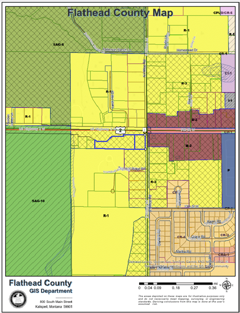
The Board of Commissioners of Flathead County, Montana, hereby gives notice, pursuant to Section 76-2-205(1), MCA, that it will hold a public hearing to consider a change in the zoning designation in a portion of the Columbia Falls Rural Zoning District ‘R-3 One Family Limited Residential’ to ‘B-2 General Business.’ for property located along US Highway 2 W near Kalispell, Montana.
The boundaries of the areas proposed to be amended from ‘R-3 One Family Limited Residential’ to ‘B-2 General Business’ are described as:
110 S. HILLTOP ROAD:
That Portion Of The Northeast Quarter Of The Northeast Quarter (Ne¼Ne¼) Of Section 13, Township 30 North, Range 21 West, Flathead County, Montana And More Particularly Described As Follows: Commencing At The Ne Corner Of Section 13, Which Point Is On The Centerline Of Montana Highway No. 40; Thence Along The Center Line West A Distance Of 30.00 Feet; Thence South A Distance Of 50.00 Feet To A Point In The South Line Of Highway No. 40 At The Point Of Beginning; Thence Along The South Line West A Distance Of 185.34 Feet; Thence South A Distance Of 282.50 Feet; Thence East A Distance Of 185.34 Feet; Thence North A Distance Of 282.50 Feet To The Point Of Beginning. Excepting Therefrom That Portion Conveyed To The State Of Montana For Highway Purposes, By Instrument Recorded August 1, 1979 Under Recorder's Fee No. 11428, In Book 675, Page 129, Records Of Flathead County, Montana.
6470 US HIGHWAY 2 WEST:
A Tract Of Land In The North Half Of The North Half Of The Northeast Quarter Of The Northeast Quarter Of Section 13, Township 30 North, Range 21 West, M.P.M., Flathead County, Montana More Particularly Described As Follows: Commencing At The Northeast Corner Of Said Section 13; Thence Southerly Along The East Boundary Of Said Section 13, A Distance Of 50 Feet; Thence North 89°46' West, A Distance Of 30 Feet To A Point, Which Is The Place Of Beginning Of The Tract To Be Described Herein, And Which Point Is At The Intersection Of The South Boundary Of Highway No. 40 And The West Boundary Of A County Road; Thence From Said Place Of Beginning Southerly And Parallel With The East Boundary Of Said Section 13, A Distance Of 282.5 Feet; Thence North 89°46' West, A Distance Of 1,290 Feet; Thence North, A Distance Of 57.5 Feet; Thence South 89°46' East, A Distance Of 125 Feet; Thence North, A Distance Of 245 Feet To A Point On The South Boundary Of Highway No. 40; Thence South 89°46' East, A Distance Of 747.3 Feet Along The South Boundary Of Highway No. 40; Thence South, A Distance Of 20 Feet; Thence South 89°46' East, A Distance Of 417.7 Feet Along The South Boundary Of Highway No. 40 To The Place Of Beginning. Excepting Therefrom That Portion Conveyed To The State Of Montana In Bargain And Sale Deed Recorded April 16, 1979, In Book 667 At Page 71, As Doc. No. 5185, Records Of Flathead County, Montana. Further Excepting Therefrom The Following 4 Parcels: Parcel 1: A Tract, Piece Or Parcel Of Land Situate, Lying And Being In The Northeast Quarter Of The Northeast Township 30 North, Range 21 West, P.M.M., Flathead County, Montana And More Particularly Described As Follows: Commencing At The Northeast Corner Of The Northeast Quarter Of The Northeast Quarter Of Section 13; Thence North 89°56' West And Along The Northerly Boundary Line Of The Northeast Quarter Of The Northeast Quarter, A Distance Of 1,194.0 Feet To A Point; Thence South 00°17' East A Distance Of 275.0 Feet To The Southeast Corner Of That Certain Tract Of Land As Described In Book 492 And Page 759 Of The Official Records Of Flathead County, Montana And The True Point Of Beginning Of The Tract Of Land Being Described; Thence South 00°17' East And On The Southerly Continuation Of The Easterly Boundary Line Of The Aforementioned Property, A Distance Of 57.5 Feet To A Point; Thence North 89°56' West And Parallel To The Southerly Boundary Line Of The Property Mentioned, A Distance Of 125.0 Feet To A Point; Thence North 00°17' West, A Distance Of 57.5 Feet To The Southwest Corner Of The Property Being Heretofore Mentioned; Thence South 89°56' East And Along The Southerly Boundary Line Of Said Property, A Distance Of 125.0 Feet To The Point Of Beginning. Parcel 2: A Tract, Piece Or Parcel Of Land Situate, Lying And Being In The Northeast Quarter Of The Northeast Quarter Of Section 13, Township 30 North, Range 21 West, P.M.M., Flathead County, Montana And More Particularly Described As Follows: Commencing At The Northeast Corner Of The Northeast Quarter Of The Northeast Quarter Of Section 13; Thence North 89°56' West And Along The Northerly Boundary Line Of The Northeast Quarter Of The Northeast Quarter, A Distance Of 1,050.0 Feet To A Point; Thence South 00°17' East And Parallel To The Easterly Boundary Line Of The Northeast Quarter Of The Northeast Quarter, A Distance Of 30.0 Feet To A Point On The Southerly Boundary Line Of Montana Highway No. 40 And The True Point Of Beginning Of The Tract Of Land Being Described; Thence South 00°17' East And Parallel To The Easterly Boundary Line Of Said Northeast Quarter Of The Northeast Quarter, A Distance Of 302.5 Feet To A Point Thence North 89°56' West And Parallel To The Northerly Boundary Line Of The Northeast Quarter Of The Northeast Quarter, A Distance Of 144.0 Feet To A Point; Thence North 00°17' West, A Distance Of 302.5 Feet To The Northeast Corner Of That Certain Tract Of Land As Recorded In Book 492 And Page 759 Of The Official Records Of Flathead County, Montana, Said Point Also Being On The Southerly Boundary Line Of Montana Highway No. 40; Thence South 89°56' East And Along The Southerly Boundary Line Of Said Highway, A Distance Of 144.0 Feet To The Point Of Beginning, Excepting Therefrom That Portion Conveyed To The State Of Montana In Bargain And Sale Deed Recorded May 30, 1979, In Book 667 At Page 967, As Doc. No. 7758, Records Of Flathead County, Montana. Parcel 3: A Tract, Piece Or Parcel Of Land Situate, Lying And Being In The Northeast Quarter Of The Northeast Quarter Of Section 13, Township 30 North, Range 21 West, P.M.M., Flathead County, Montana And More Particularly Described As Follows: Commencing At The Northeast Corner Of The Northeast Quarter Of The Northeast Quarter Of Section 13; Thence North 89'56 West And Along The Northerly Boundary Line Of The Northeast Quarter Of The Northeast Quarter, A Distance Of 906.0 Feet To A Point; Thence South 00°17' East And Parallel To The Easterly Boundary Line Of The Northeast Quarter Of The Northeast Quarter, A Distance Of 30.0 Feet To A Point On The Southerly Boundary Line Of Montana Highway No. 40 And The True Point Of Beginning Of The Tract Of Land Being Described; Thence South 00'17' East And Parallel To The Easterly Boundary Line Of Said Northeast Quarter Of The Northeast Quarter, A Distance Of 302.5 Feet To A Point; Thence North 89°56' West, A Distance Of 144.0 Feet To A Point; Thence North 00°17' West And Parallel To The East Line Of The Property Being Described, A Distance Of 302.5 Feet To A Point On The Southerly Boundary Line Of Montana No. 40; Thence South 89°56' East And Long The Southerly Boundary Line Of Said No. 40, A Distance Of 144.0 Feet To The True Point Of Beginning. Excepting Therefrom That Portion Conveyed To The State Of Montana In Bargain And Sale Deed Recorded May 30, 1979, In Book 667 At Page 972, As Doc. No. 7796, Records Of Flathead County, Montana. Parcel 4: That Portion Of The Northeast Quarter Of The Northeast Quarter, Section 13, Township 30 North, Range 21 West, Flathead County, Montana, Described As Follows: Commencing At The Northeast Corner Of Section 13, Which Point Is On The Centerline Of Montana Highway No. 40; Thence Along The Centerline West, A Distance Of 30.00 Feet; Thence South, A Distance Of 50.00 Feet To A Point On The South Line Of Highway No. 40 At The Point Of Beginning; Thence Along The South Line West, A Distance Of 185.34 Feet; Thence South, A Distance Of 282.50 Feet; Thence East, A Distance Of 185.34 Feet; Thence North, A Distance Of 282.50 Feet To The Point Of Beginning. Excepting Therefrom That Portion Conveyed To The State Of Montana In Bargain And Sale Deed Recorded August 1, 1979, In Book 675 At Page 129, As Doc. No. 11428, Records Of Flathead County, Montana.
The regulations defining the R-3 and B-2 zones are contained in the Flathead County Zoning Regulations on file for public inspection at the Office of the Board of Commissioners, 800 South Main, Room 302, Kalispell, Montana, at the Flathead County Planning and Zoning Office, 40 11th Street West, Kalispell, Montana, and on the Flathead County Planning and Zoning Office’s website at: https://flatheadcounty.gov/department-directory/planning-zoning/draft-documents. Documents related to the proposed zone change are also on file for public inspection at the Commissioners’ Office and at the Flathead County Planning and Zoning Office.
The public hearing will be held on the 28th day of July, 2026 at 10 o'clock a.m. in the Commissioners’ Chambers, Third Floor, Courthouse, Kalispell, Montana. At the public hearing, the Board of Commissioners will give the public an opportunity to be heard regarding the proposed change to the West Side Zoning District.
Written comments are encouraged and will be reviewed by the Commissioners if received prior to the hearing.
DATED this 30th day of June, 2026.
BOARD OF COUNTY COMMISSIONERS
Flathead County,
By: _/s/Brad W. Abell__________
Brad W. Abell, Chair
Publish on July 14 and 21, 2026.
Figure 1: Subject property (outlined in blue)