NOTICE OF PUBLIC HEARING
The Board of Commissioners of Flathead County, Montana, hereby gives notice, pursuant to Section 76-2-205(1), M.C.A., that it will hold a public hearing to consider the creation of a new zoning district to be known as the Columbia Falls Rural Zoning District.
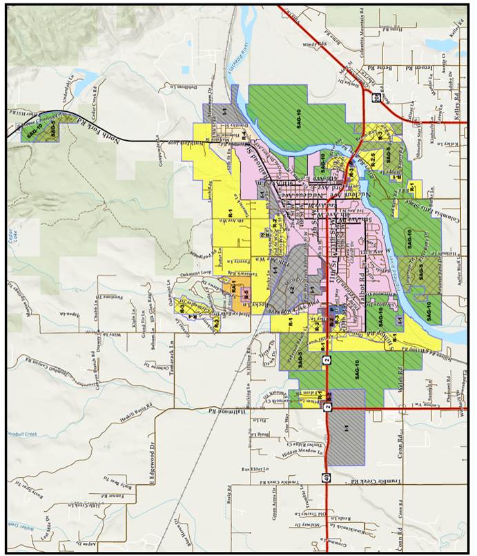
The boundaries of the proposed district which would include the SAG-10 (Suburban Agricultural), SAG-5 (Suburban Agricultural), R-2.5 (Rural Residential), R-1 (Suburban Residential), R-2 (One Family Limited Residential), R-3 (One Family Residential), R-4 (Two-Family Residential), R-5 (Two-Family Residential), RA-1 (Residential Apartment), P (Public), B-2(General Business), B-5 (Resort Business), I-1 (Light Industrial), and I-2 (Heavy Industrial) zones are described as:
Beginning at the North quarter corner of 28-31-20 thence East to the West boundary of the North Fork Flathead Highway.
Thence Southeasterly along the West boundary of the North Fork Flathead Highway to the West boundary of the NENE quarter. Thence South to the SW corner of the NENE quarter.
Thence, along the north boundary of the SENE quarter to the West boundary of the North Fork Flathead Highway.
Thence Southerly following the West boundary of the North Fork Flathead Highway to the North boundary of the SESE quarter.
Thence West to the NW corner of the SESE.
Thence North to the NW corner of the NESE.
Thence west to the SW corner of the SWNE.
Thence North along the west boundary of the NE quarter to the NW corner of the NE quarter and the Point of beginning.
Also, beginning at the NE corner of Lot 3 of Garnier Creek Estates that is located in 6-30-20.
Thence East along the North boundary of 06-30-20 to the point of extension of the east boundary of Lot 74 and the North boundary of 06-30-20.
Thence Southerly through Open Space 6 of Tamarack Heights PH 1 to the NE corner of Lot 74 of Tamarack Heights PH 1.
Thence continuing Southerly on and along the Easterly boundary of Tamarack Heights PH 1 to the north boundary of the NESW.
Thence West to the NW corner of the NESW quarter
Thence south to the SE corner of Open Space D of Mountain Watch Subdivision.
Thence on and along the southerly boundary of Mountain Watch to the West boundary of section 6-30-20.
Thence North to the West quarter corner of 6-30-20.c
Thence East to the SW corner of COS 13198-2.
Thence North on and along the Westerly boundary of COS 13198-2 to the center of Garnier Creek.
Thence along the East boundary of Garnier Creek Estates to the NE corner of Lot 3 of Garnier Creek Estates and the Point of beginning.
Also, beginning at the NW corner of NESE of 6-30-20; thence Easterly to the West quarter corner of 5-30-20.
Continuing Easterly to the SW corner of the SENE quarter of 5-30-20.
Thence North to the NW corner of the S1/2 SENE.
Thence Easterly along said S1/2 SENE to the NE corner of S1/2 SENE and the West boundary of 4-30-20.
Thence North to the NW corner of the SWNW of 4-30-20.
Thence easterly to the NE corner of the SWNW.
Thence North along the NENW to the NW corner of COS 22802-1.
Thence Easterly along the North boundary of said COS 2282-1 and Lot 6 of Staalesons Acres to the West boundary of North Fork Flathead Highway.
Thence following the extension of the North boundary of Lot 6 Staalesons Acres to the East boundary of North Fork Flathead Highway in the NWNE.
Thence, South along the East boundary of the North Fork Flathead Highway to the North boundary of the SWNE.
Thence, East to the NE corner of the SWNE.
Thence South to the NW corner of the South ½ of the SENE.
Thence East along the S2SENE to the West boundary of 3-30-20.
Thence South along the West boundary of 3-30-20 to the NW corner of the SWSW of 3-30-20.
Thence East to the NE corner of the SWSW quarter.
Thence Southerly to the SE corner of the SWSW quarter and the North boundary of 10-30-20.
Continuing South along West 1/16th quarter line to the SE corner of the NWSW quarter of 10-30-20.
Thence West to the NW corner of the SWSW quarter and the East boundary of 9-30-20.
Thence South along the East boundary to the SE corner of said 9-30-20.
Continuing South to the SE corner of NENE on the East boundary of 16-30-20.
Thence West to the SW corner of NENE of 16-30-20.
Thence South along the East 1/16 quarter line to the SE corner of the SWSE of said 16-30-20.
Thence Southerly along the East 1/16 boundary of 21-30-20 to the South boundary of Rogers RD.
Thence Westerly following the South boundary of Rogers RD to the East Boundary of the NWNW of 21-30-20.
Thence South to the SE corner of the N1/2NWNW.
Thence West to the SW corner of the N1/2NWNW and the East boundary of 20-30-20.
Thence South to the SE corner of Lot 1 of Subdivision NO 193.
Thence West to the NW corner of Lot 1 Burke Subdivision.
Thence South to the SE corner of the N1/2SWNE
Thence South to the SE corner of said NW quarter.
Thence West to the SW corner of the NW quarter of 20-30-20.
Thence continuing West along the mid-section line to the West quarter of 19-30-20.
Thence continuing West along the mid-section line to the SW corner of the SENE of 24-30-21.
Thence North to the NW corner of SENE.
Thence West to the SW corner of the NWNE.
Thence North to the NW corner of the NWNE and the South boundary of 13-30-21.
Thence West along the South boundary of 13-30-21 to the SW corner of the SESW.
Thence North to the NW corner of the SESW.
Thence West to the SW corner of the NWSW.
Thence Northerly along the West boundary of 13-30-21 to the East quarter corner of 14-30-21
Thence West along the mid-section line of 14-30-21 to the SW corner of the SENW.
Thence North along the West 1/16 line to the NW corner of the NENW.
Thence East along the North boundary to the NE corner of 14-30-21.
Thence North along the West boundary of 12-30-21 to the West quarter corner.
Thence East along the mid-section line to the NE corner of the NWSW of 12-30-21.
Thence South to the NW corner of the S1/2 NESW.
Thence East to the NW corner of the SENESW of 12-30-21.
Thence North to the NW corner of the NENESW of 12-30-21.
Thence East to the NE corner of the NESW of 12-30-21.
Thence North to the NW corner of the SWSWNE of 12-30-21.
Thence Easterly along the south boundary of Hilltop Terrace Unit NO 2 to the East boundary of 12-30-21.
Thence North to the NW corner of the SWNW in 7-30-20.
Thence East to the NE corner of the SWNW.
Thence North to the NW corner of the NENW.
Thence East along the South boundary of 6-30-20 to the southerly extension of the East boundary of Meadow Lake Drive.
Thence Northerly along said Meadow Lake Drive to the SW corner of Lot 39 of Meadow Lake Estates.
Thence Easterly and Northerly around the boundary of said Lot 39 of Meadow Lake Estates to the North boundary of the SESW.
Thence East along said North boundary of the SESW to the West boundary of Lot 12Z of the Meadow Lake County Club Estate Ph 1.
Continuing along the West boundary of Meadow Lake Country Club Estates PH 1 to the NW corner of Lot 24Z
Thence Easterly along an extension of the North line of Lot 24Z of Meadow Lake Country Club Estates PH 1 to the East boundary of Spyglass Hill Way.
Thence Northerly along Spyglass Hill Way to the Northeasterly side of St Andrews Dr.
Thence Southerly along the East boundary of St Andrews Dr to the NW corner of Lot 38R of Meadow Lake Country Club Estates PH 7A.
Thence East to the NE corner of Lot 38R of Meadow Lake Country Club Estates PH 7A.
Thence North to the NW corner of the NESE and the Point of Beginning.
Excepting there from properties within the Columbia Falls City Limits and the Flathead River.
The regulations defining the zoning use districts are contained in the Flathead County Zoning Regulations and are on file for public inspection at the Office of the County Commissioners, located at 800 South Main, Kalispell, Montana, the Flathead County Planning and Zoning Office, 40 11th Street West, Ste. 220 Kalispell, Montana, and on the Flathead County Planning and Zoning Office’s website, at https://flatheadcounty.gov/department-directory/planning-zoning/zoning-information. Documents related to the proposed zoning district are on file for public inspection at the Office of the County Commissioners, at the Flathead County Planning and Zoning Office, and on the Flathead County Planning and Zoning Office’s website, at https://flatheadcounty.gov/department-directory/planning-zoning/columbia-falls-zoning.
The public hearing will be held on the 19th day of August, 2025, at 10:15 a.m., in the Chambers of the Board of Commissioners of Flathead County, Third Floor, Old Courthouse, Kalispell, Montana. At the public hearing, the Board of Commissioners will give the public an opportunity to be heard regarding the proposed zoning District.
Written comments are encouraged and will be reviewed by the Commissioners prior to the hearing if received by the Flathead County Commissioners’ Office at least three business days prior to the hearing.
DATED this 26th day of June, 2025.
BOARD OF COUNTY COMMISSIONERS
Flathead County,
By:_/s/Pamela J. Holmquist_________
Pamela J. Holmquist, Chair
Publish on August 5 and 12, 2025.
Exhibit A: Draft Map of Proposed Zoning District