NOTICE OF PUBLIC HEARING
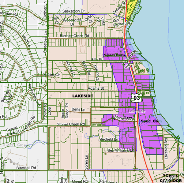
The Board of Commissioners of Flathead County, Montana, hereby gives notice, pursuant to Section 76-2-205(1), M.C.A., that it will hold a public hearing to consider a change to the zoning designation of the Lakeside Zoning District from LS Lakeside to LSR Lakeside Residential and LSC Lakeside Commercial for properties approximately bounded by Bierney Creek Road to the north, Flathead Lake to the east, Blacktail Road to the south and Stoner Creek Road and Grayling Road to the west.
The boundaries of the area proposed to be amended from LS Lakeside to LSR Lakeside Residential and LSC Lakeside Commercial are described as:
Lakeside Residential:
Located in Sections 7 and 18 of Township 26 North, Range 20 West, P. M. M. Flathead County Montana.
Commencing at the West quarter corner of said Section 7-26-20. Thence south along the West boundary of Section 7 to the southwest corner of Tract 1 of COS 14159 and being the Point of Beginning. Thence continuing South along the West boundary to the SW corner of Section 7. Thence continuing South along the West boundary of Section 18-26-20 to the SW corner of the SWNW and the centerline of Blacktail Road. Thence easterly along said centerline of Blacktail Road to the NE corner of Tract A of COS 11140. Thence South to the south line of Blacktail Road. Thence East on and along the southerly line of Blacktail Road to the west boundary of Highway 93. Thence continuing easterly on an extension of said southerly line of Blacktail Road to the East boundary of Highway 93. Thence northwesterly along Highway 93 to the north line of the NWSE. Thence Easterly along the North line of the NWSE quarter to the East side of the county road shown on Clearview Lakeside Tracts Plat. Thence along the East side of the county road as shown on Clearview Lakeside Tracts to the East boundary of SWNE. Thence North to the boundary of Flathead Lake. Thence northwesterly along the boundary of Flathead Lake to the SE corner of Parcel A of COS 9268. Thence West along the south boundary of Parcel A of COS 9268 to the NE corner of Parcel A of COS 9576. Thence southerly to the SE corner of said Parcel A of COS 9576. Thence easterly to the NE corner of Parcel B of COS 10047. Thence south to the SE corner of said Parcel B of COS 10047. Thence Easterly along the South boundary of Parcel C of COS 10047 to the West boundary of Lakeside Ave. Then, southerly along the West boundary of Lakeside Ave to the North boundary of Abandoned Road Woodland Avenue. Thence Westerly along the North boundary of abandoned Woodlawn Avenue to the East boundary of Highway 93. Thence northwesterly along the east boundary of Highway 93 to a point that is the extension of the north boundary of Ben Williams Lane. Thence West along said extension of the North boundary of Ben Williams Lane and continuing on that line to the SW corner of Lot 5 of Blacktail Estates. Thence North along the West boundary of Lot 5 of Blacktail Estates to the NW corner of said Lot 5. Thence East along the North boundary of Lot 5 of Blacktail Estates to the SW corner of Tract shown on COS 2004. Thence North to the NE corner of Tract 3 of COS 17625. Thence West along the approximate thread of Stoner Creek to the SW corner of the tract shown on COS 19739. Thence northerly along the West boundary of COS 19739 to the south boundary of the NENW. Thence Westerly to the SW corner of the NENW. Thence North along the west boundary of the NENW to the SW corner of Tract 5 of COS 22313. Thence easterly along the south boundary and then northerly along the east boundary of Tract 5 of COS 22313 to the NW corner of Tract 2 of COS 22313. Thence easterly to a point that is the southerly extension of the west line of a Tract of land recorded on QCD 202200008802 to the D. A. Anderson Revocable Living Trust. Thence Northerly to the NW corner of Block 5 Lacon and the south boundary of 18-26-20. Thence West to the SW corner of COS 3366. Thence Northerly to the NW corner of Lot 4 of Pandas Corner. Thence East to the NE corner of Lot 1 Pandas Corner. Thence Northwesterly along west boundary of Highway 93 to the SE corner of Parcel B of COS 9244. Thence West to the SW corner of Parcel A of COS 9244. Thence Northerly to the NE corner of Parcel 2 of COS 18846. Thence Easterly to the SE corner of Lot 11 of Savage Lakeside Lots. Thence Northerly along the East boundary of Lot 11 of Savage Lakeside Lots to the NE corner. Thence Easterly along the North boundary of the SWSE quarter to Flathead Lake. Thence northerly along Flathead Lake to the south boundary of Tract 3 of COS 19168. Thence along the south boundary of Tract 3 of COS 19168 and continuing northwesterly to the SW corner of Tract 3 of COS 19168. Thence continuing on an extension of the South boundary of Tract 3 of COS 19168 to the West boundary of Highway 93. Thence continuing on that same line to the West boundary of Craven Street. Thence continuing westerly to the SW corner of COS 5637. Thence continuing westerly to the SW Corner of Tract 1 of COS 14159 and the POB
Lakeside Commercial:
Located in Sections 7 and 18 of Township 26 North, Range 20 West, P. M. M. Flathead County Montana. Commencing at the northwest corner of the SWSW of said Section 7-26-20. Thence East to the NW corner of Lot 10 of Savage Lakeside Lots and the Point of Beginning. Thence continuing Easterly along the North boundary of Savage Lakeside Lots and the North Boundary of SESW to the boundary of Flathead Lake. Thence southerly along the boundary of Flathead Lake to SE corner of COS 9268. Thence Westerly to the NE corner of Parcel A of COS 9576. Thence southerly to the SE corner of said Parcel A of COS 9576. Thence easterly to the NE corner of Parcel B of COS 10047. Thence south to the SE corner of said Parcel B of COS 10047. Thence Easterly along the South boundary of Parcel C of COS 10047 to the West boundary of Lakeside Ave. Then, southerly along the West boundary of Lakeside Ave to the North boundary of Abandoned Road Woodland Avenue. Thence Westerly along the North boundary of abandoned Woodlawn Avenue to the East boundary of Highway 93. Thence northwesterly along the east boundary of Highway 93 to a point that is the extension of the north boundary of Ben Williams Lane. Thence West along said extension of the North boundary of Ben Williams Lane and continuing on that line to the SW corner of Lot 5 of Blacktail Estates. Thence North along the West boundary of Lot 5 of Blacktail Estates to the NW corner of said Lot 5. Thence East along the North boundary of Lot 5 of Blacktail Estates to the SW corner of Tract shown on COS 2004. Thence North to the NE corner of Tract 3 of COS 17625. Thence West along the approximate thread of Stoner Creek to the SW corner of the tract shown on COS 19739. Thence northerly along the West boundary of COS 19739 to the south boundary of the NENW. Thence Westerly to the SW corner of the NENW. Thence North along the west boundary of the NENW to the SW corner of Tract 5 of COS 22313. Thence easterly along the south boundary and northerly along the east boundary of Tract 5 of COS 22313 to the NW corner of Tract 2 of COS 22313. Thence easterly to a point that is the southerly extension of the west line of a Tract of land recorded on QCD 202200008802 to the D. A. Anderson Revocable Living Trust. Thence Northerly to the NW corner of Block 5 Lacon and the north boundary of 18-26-20. Thence West to the SW corner of COS 3366. Thence Northerly to the NW corner of Lot 4 of Pandas Corner. Thence East to the NE corner of Lot 1 Pandas Corner. Thence Northwesterly along the west boundary of Highway 93 to the SE corner of Parcel B of COS 9244. Thence West to the SW corner of Parcel A of COS 9244. Thence Northerly to the NE corner of Parcel 2 of COS 18846. Thence Easterly to the SE corner of Lot 11 of Savage Lakeside Lots. Thence Northerly along the West boundary of Lot 10 of Savage Lakeside Lots to the NW corner of said Lot 10 and the POB.
The regulations defining the LS, LSR, and LSC zones are contained in the Flathead County Zoning Regulations on file for public inspection at the Office of the Board of Commissioners, 800 South Main, Room 302, Kalispell, Montana, at the Flathead County Planning and Zoning Office, 40 11th Street West, Kalispell, Montana, and on the Flathead County Planning and Zoning Office’s website at: https://flatheadcounty.gov/department-directory/planning-zoning/meeting-information. Documents related to the proposed zone change are also on file for public inspection at the Commissioners’ Office and at the Flathead County Planning and Zoning Office.
The public hearing will be held on the 28th day of August, 2025 at 10 o'clock a.m. in the Commissioners’ Chambers, Third Floor, Courthouse, Kalispell, Montana. At the public hearing, the Board of Commissioners will give the public an opportunity to be heard regarding the proposed change to the Lakeside Zoning District.
Written comments are encouraged and will be reviewed by the Commissioners if received prior to the hearing.
DATED this 8th day of July, 2025.
BOARD OF COUNTY COMMISSIONERS
Flathead County,
By: _/s/Brad W. Abell PT________
Pamela J. Holmquist, Chairman
Publish on August 14 and 21, 2025.
Figure 1: Subject property (outlined in red)